Shortly after the start of the war in Ukraine, academics began actively collecting data on suspected mass grave sites in an effort to better understand how to document their locations in real-time using open sources. This study also aimed to test the effectiveness of tools developed to support the process of mapping such places. This is stated in an analytical article by Ellie Smith and Melanie Klinkner, researchers at Bournemouth University (Great Britain), published on platform The Conversation.
Studying the places of mass burials has become an extremely difficult task. The Internet was flooded with information from various sources, from eyewitnesses to journalists and analysts. The large volume of materials required careful analysis to determine reliable data, check for errors or deliberate distortions, and correctly document these locations.
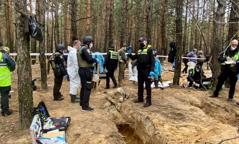
The researchers were working in an environment where the situation was constantly changing, so it was necessary to quickly track possible burial sites, transfer information to the relevant authorities, initiate official investigations, and then exhume and identify the bodies. The speed of mapping became critical to capture these events before circumstances changed.
The project turned out to be difficult psychologically. As Diego Núñez, a data scientist for the Mass Grave Protection, Investigation and Engagement (MaGPIE) project, noted, even experienced analysts feel vulnerable to the scale of evidence of human rights abuses. Each mass grave told its own story of horror, which is difficult to erase from memory. From photographs of the remains of the victims to the testimonies of eyewitnesses, these data did not leave even hardened researchers indifferent.
One of the main problems was obtaining reliable information from the territories occupied by Russia in the east of Ukraine. Only after the retreat of Russian troops from certain areas did more facts appear, which made it possible to supplement the map. The absence of data or their distortion could lead to political manipulation of information by the aggressor.
At the same time, the difficulty of obtaining data during conflicts is not only a scientific challenge, but also a source of unbearable pain for the relatives of the missing. That is why scientists have set themselves the goal of creating the world’s first global open-source digital map of mass graves. Such a map can become a symbolic form of memory perpetuation, especially in those places where political or ethnic conflicts do not allow it to be done physically. Open access to this information will also help counter attempts to deny crimes and rewrite history.
In parallel, the researchers conducted a large-scale study of the practices of investigating mass graves in different countries of the world, which allowed the development of an international protocol of standards for the protection of such places and the conduct of their investigations.


