Remote inspection of property in the area of military operations: how to do it and what lawyers advise
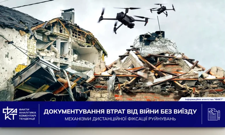
The issue of compensation to citizens for property destroyed as a result of hostilities remains one of the most difficult in the context of a full-scale war. This problem is particularly acute in situations where people have lost access to their property due to hostilities, occupation or mine danger. In such cases, there is a need to record the fact of destruction without a physical inspection, that is, remotely. It is this form of examination that raises many questions from the affected citizens: will such evidence be accepted? Who should collect them? What to do in case of refusal?
In response to the request of the IA “FACT” editors, the lawyers of the “Repeshko and Partners” Bar Association explained what legal mechanisms are currently provided for the remote inspection of destroyed property, how to record it in a combat zone, and what every applicant who submits documents for compensation in conditions where personal travel to the place is impossible or dangerous should take into account.
Currently, the issue of compensation to citizens for real estate destroyed during hostilities is really very acute. And if everything is clear with an apartment in Kyiv or a house in Kharkiv, the mechanism has been worked out, even among lawyers the question remained open until now: what to do with the immovable property of citizens, which was destroyed in the zone of active hostilities, but no commission will go there without an inspection?
Internally displaced persons from such settlements have been in a state of limbo since the beginning of the war, because they had no actual opportunity to receive compensation for their housing, which no longer exists, and to use the funds received to start a new life in another city. Modern technologies came to the rescue in this case.
On July 7, 2025, the Cabinet of Ministers of Ukraine approved Resolution No. 815, which regulates the specifics of conducting a remote survey of destroyed individual categories of real estate objects located in the territories of active hostilities, territories of active hostilities, where state electronic information resources function. This resolution regulated the mechanism of surveying destroyed individual categories of real estate objects using remote monitoring products.
The provisions of this normative act are used in order to record the fact of destruction of certain types of immovable property located in territories where hostilities are ongoing or have been ongoing. We are talking about those settlements that are included in the official list of territories of hostilities or temporarily occupied by the Russian Federation, approved by the Ministry of Community Development, Territories and Infrastructure. The document also applies to those cases when state electronic information resources work in these territories, but it is not possible to carry out a normal survey, as provided for by the Procedure for the implementation of urgent works for the elimination of the consequences of war, if it is a question of damaged buildings or structures. That is, the document is used precisely when it is impossible for objective reasons to conduct a standard professional examination on the spot.
However, unfortunately, this resolution is not applied to the survey of certain categories of real estate objects located on the territory of Ukraine temporarily occupied by the Russian Federation, determined in accordance with Law of Ukraine “On ensuring the rights and freedoms of citizens and the legal regime in the temporarily occupied territory of Ukraine” and the list of territories on which hostilities are (were) conducted or temporarily occupied by the Russian Federation, approved by the Ministry of Development.
Remote survey currently refers to the process of collecting, recording and analyzing information about the state of an object of immovable property without physical access to it using photo and video materials obtained with the help of digital cameras (in particular, mobile devices), unmanned aerial vehicles or other technical means of remote observation, in particular information products of remote sensing of the Earth.
It should be noted that certain categories of real estate objects (hereinafter referred to as objects) are subject to inspection according to this resolution, namely, residential buildings, manor-type houses, garden and country houses (in particular, apartments, other residential premises located in such buildings).
Therefore, according to the adopted norms, those real estate objects which, according to the preliminary information available to the authorized body – it can be either the territorial community or the relevant military administration – are considered to be destroyed, are subject to remote inspection. It is about those buildings that are located in the territories of hostilities or temporary occupation, as provided for in the mentioned list. However, the main condition is the following – in these territories, it is not possible to conduct other, ordinary types of survey, which are usually used to fix destruction. In this case, it is allowed to use the remote format as an exclusive form of documentation of losses.
The following types of remote monitoring products may be used by the authorized body during a remote inspection:
1) photographic materials obtained with the help of digital cameras (in particular, mobile devices), unmanned aerial vehicles, etc.;
2) video materials obtained with the help of video cameras (in particular, mobile devices), unmanned aerial vehicles, etc.;
3) information products of remote sensing of the Earth.
Such materials that can be used during a remote examination include:
– materials and data of aerial photography, as well as space photography, together with the corresponding metadata, which are presented in the form of visual images. These images must cover the boundaries of the subject, be presented in their original form with a unique name, and not undergo file compression.
– processed originals of the same materials (i.e. aerial and space survey data) together with their metadata. They also have the appearance of visual images within the respective subject, saved in an unaltered format, with a unique name and without compression. In the normative document, these visual materials are further referred to as “images of objects”.
It is worth knowing that in order to increase the accuracy and reliability of the interpretation of remote survey data and to increase the level of validity of the conclusions obtained from the results of such survey, all available types of remote monitoring products are used.
In the case of using photographic materials for the purposes of conducting a remote survey of destroyed objects, the images must meet the specified characteristics. First, technical requirements for images are put forward. The photo must be in a color format with a resolution that allows you to visually confirm the fact that the object has been destroyed. The image in the photograph must be clear, without signs of digital distortion, blurring or other defects that make it impossible to identify the object or the nature of its damage or destruction. Shooting should be carried out in conditions of sufficient natural or artificial lighting that ensures proper visibility of details. If technically possible, the picture file should contain embedded metadata (EXIF), in particular, recording the date and time of the picture, the coordinates of the global navigation satellite system of the place where the picture was taken, as well as technical information about the device that was used to take the picture.
Second, the minimum set of images of an object should include several specific angles. An image of the general appearance of the land on which the object is located, together with the surrounding area, must be provided – this is necessary to confirm the type and location of the object. There should also be a general perspective (view) of the object itself, which makes it possible to assess the degree of its damage or destruction. In addition, it is necessary to provide at least three angles: the facade, the side facade (view from the opposite side, i.e. the back side) and/or a photograph from above – they must confirm the fact of the destruction of the object.
Thirdly, there are separate requirements for the content of the image. The destroyed structures (elements) of the object must be clearly recorded on the picture. It is, in particular, about the destruction or collapse, that is, the loss of the integrity of the load-bearing and enclosing structures – walls, ceilings, roofs. The image should provide a contrasting image of the preserved and destroyed parts of the object – in the case of partial destruction. In addition, if possible, the photo should contain identifying features of the object itself – for example, address plates, house numbers, signs, the surrounding area or landmarks that can be used to clearly identify the place where the photo was taken.
We would like to emphasize that in the case of using for the purposes of conducting a remote survey video materials obtained, in particular, from unmanned aircraft, the video recording must meet a number of specified requirements. As for the technical characteristics, the resolution of the video should not be lower than 1920 × 1080 pixels. The video file format must be a standard digital format with minimal compression, such as MP4 or MOV. The duration of the video should be sufficient to provide a complete overview of the damage or destruction of the object and the surrounding area.
At the same time, the video must be continuous – no montage, gluing of individual fragments or acceleration of playback is allowed. If technically possible, the video file should contain embedded metadata (EXIF), which includes recording the date and time of the recording, the global navigation satellite system coordinates of the location of the recording, as well as technical information about the device that was used to record the video.
At the same time, there are clear requirements for the content of the video file itself. In particular, the video should provide a complete and clear visual representation of the object. This means that the video recording should contain an overview of the general condition of the object from different angles, including taking into account the surrounding area. Detailing of existing signs of destruction, such as collapse or other damage to supporting and enclosing structures, must be provided. It is also mandatory to visually fix the reference to the terrain – this can be done through the display of landmark objects, terrain elements or coordinates that make it possible to uniquely identify the location of the shooting.
In addition, in the case of using the information products of remote sensing of the Earth for remote survey, the images of the objects must meet the established characteristics. In particular, the recommended geometric projection of a picture pixel is 50 centimeters per pixel. In the case of using images with other pixel projection characteristics, the quality of such a picture must be sufficient to allow clear signs of destruction of objects to be determined. It is also necessary to have multispectral data that provide the ability to distinguish objects based on the reflective properties of different materials.
Shooting should be done in daylight, under the condition of low cloud cover – no more than 10 percent. The shooting direction should be directly above the object, with a permissible deviation of up to 20 degrees from the nadir. In addition, the images must contain information in accordance with the international standard UTC about the date and time of capture with an accuracy of one minute (if available), as well as information about the geolocation of the object data. At the same time, the permissible error of geolocation should not exceed four meters.
The sources of obtaining data on information products of remote sensing of the Earth are national and foreign systems of remote sensing of the Earth, the geoinformation system of the State Cartographic and Geodetic Fund of Ukraine, public electronic registers of the Ministry of Defense, as well as other sources not prohibited by law. Remote examination is carried out by a commission formed in accordance with The procedure for the implementation of urgent works related to the elimination of the consequences of the armed aggression of the Russian Federation, related to the damage to buildings and structures, on the basis of an information notice about damaged and destroyed real estate.
Landmark objects, to which reference is made during the survey, are objects of natural (territory features, relief, landscape elements, water bodies, etc.) or artificial (buildings and structures) origin, the geographical location of which is known and which have unique or characteristic features that visually make it possible to identify them on photo or video materials or information products of remote sensing of the Earth, which are used for remote examination.
During a remote survey, the commission conducts a collective analysis of all available remote monitoring products that contain information about the object being surveyed, with the aim of establishing the fact of the destruction of the object.
It should be noted that in order to increase the accuracy of the interpretation of the data of remote monitoring products and establish the fact of the destruction of the object being surveyed, the commission also studies the following materials that must be provided to it:
- information about the characteristics of the object before destruction;
- information and documents confirming the fact of destruction of the object, in particular those that are at the disposal of the State Emergency Service, the National Police and other competent state authorities, and provided in accordance with the request of the authorized body;
- written or oral testimony of persons familiar with the circumstances of the event that led to the destruction of the object or its actual condition at the time of remote inspection;
- analytical data generated by software, in particular with the use of artificial intelligence (in the case of technical implementation).
Therefore, we advise you to prepare the documents according to this list in advance.
In the case of application by the commission for conducting a remote survey of unmanned aircraft, permission to use the airspace of Ukraine is granted by the General Staff of the Armed Forces on the basis of an application. Based on the results of the remote examination, the commission makes a decision within five working days from the date of its conduct act of remote examination for each object according to the specified form, in which the conclusion on the establishment or impossibility of establishing the fact of destruction of the object is indicated.
In the event that, based on the results of the conducted remote survey, the fact of destruction of the object is established, this means that not only the object itself as a whole, but also the apartment and other residential premises that were part of it, are officially recognized as destroyed. In other words, in case of documentary confirmation of the complete destruction of the building during remote fixation, all living quarters located in it – regardless of the form of ownership or legal status – are also considered to be destroyed at the same level as the main structure. At the same time, remote monitoring products confirming the establishment of the destruction of the object, as well as information and documents regarding the characteristics of the object before its destruction (if available) are attached to the remote inspection report.
An official designated by the authorized body, within three working days from the date of drawing up the act by the commission, registers it (together with the relevant remote monitoring materials) in the Register of damaged and destroyed property, assigning a registration number and affixing a qualified electronic signature.
The commission notifies the applicant about the results of the remote examination by sending a copy of the act of remote examination within three working days from the date of its completion by means of the Unified state web portal of electronic services (Diya Portal), in particular using the mobile application of the Diya Portal (Diya) (in case of technical implementation), or to the e-mail address specified in the information notice.
If, based on the results of the remote survey, it is not possible to clearly establish the fact of the object’s destruction, the commission makes a decision to stop such survey. This decision necessarily states that it is currently impossible to establish the fact of destruction on the basis of the provided materials.
After receiving the decision to stop the remote inspection, the applicant has the right to submit additional information about the object to the commission within 90 calendar days from the moment of receiving the relevant document. This can be done by sending a request together with new materials or evidence that can prove the fact of destruction.
Thus, the mechanism provided by the regulatory act aims to create a tool to help citizens who have lost access to their houses or apartments as a result of hostilities or occupation. Its application is intended to ensure the possibility of fixing the destroyed housing even without a physical presence on the spot. At the same time, the issue of the effectiveness of this mechanism and possible procedural complications, as well as the real chances of receiving compensation, will be assessed only in the process of practical application of the relevant regulatory act.
Citizens who have lost access to their homes as a result of hostilities or temporary occupation are advised not to delay in submitting an application for recording the damage, even if it is not possible to leave the place. In the case of using the remote inspection mechanism, it is important to immediately collect as complete a package of evidence as possible: high-quality photo and video materials, satellite images (if possible), ownership documents, previous inspection reports, eyewitness testimony. In case of receiving a decision to stop the procedure, you must use the right to submit additional information within 90 days. The correct organization of the collection of materials at this stage can significantly affect the outcome of the application review and the chances of receiving compensation.